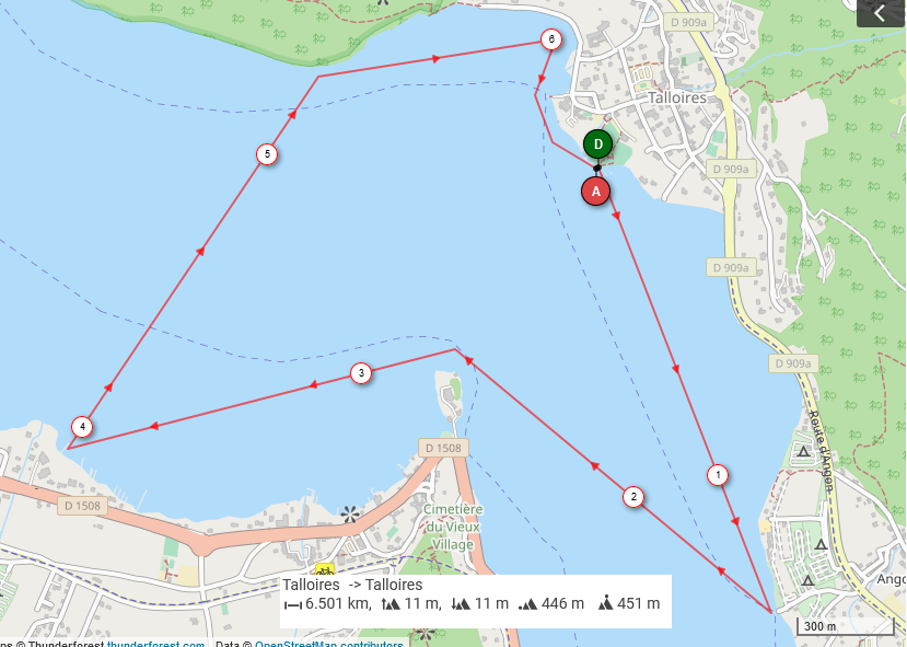
GlaGla Race Classic Course, Lake Annecy
The GlaGla Race's classic 6.5 km loop from Talloires beach: south to Angon, round the Duingt castle point, across the lake to Roc de Chère and back into Talloires bay.
Provisional line · Times: not yet
Provisional line: drawn from the organizer's course map, not yet measured. Times on it are provisional until a measured GPS trace verifies it. The map is the one the organizer published for the 2022 and 2024 editions; the course for January 2027 is not published yet. The turns are race buoys, so on your own the gates stand in for them. The Clos Marcel hotel, where the organizer turns, is not mapped in OpenStreetMap; that gate is the shoreline just east of the map's corner. Check the rules before you go: outside the race, the prefecture keeps paddle craft classed as water toys inside the inshore zone marked by yellow buoys, and most of this loop is open water.
Course Map
- Distance
- 4 mi (6.5 km)
- Laps
- 1
- Water
- Lake
- Board classes
- 14', 12'6", Unlimited, Inflatable
- Mirrors
- Short distance, 6.5 km (the classic GlaGla loop)
Gates
- Start · Start line off Talloires beach (cross the line)
- Gate · Off Angon, the southern turn on the east shore (cross the line)
- Gate · Round the Duingt castle point, heading west (cross the line)
- Gate · The Duingt shore at the Clos Marcel turn (cross the line)
- Gate · Off Roc de Chère, turning east along the shore (cross the line)
- Gate · Off the Talloires point, into the bay (cross the line)
- Finish · Finish line off Talloires beach, the start line (cross the line)
The Race It Mirrors
This course follows the Short distance, 6.5 km (the classic GlaGla loop) of GlaGla Race, Talloires-Montmin.
Course Record
No course record yet. It appears here once the race's results are in our results, from the published results only.
Reference Times
Reference times appear once the race this course mirrors is in a Power Score list.
Course Board
No course times on the board yet. Run this course with the Supconnect app and put your time on the board.
One time per paddler per board: their fastest, recorded live in the app and checked against the course. Only adults are shown.
This line is provisional, not yet measured: times on it, and their Virtual Power Score, are provisional until a measured GPS trace verifies it.
Paddlers On This Course
How Course Times Work
A course time is your time on this course, paddled on your own on a day you choose: from the start gate to the finish gate, through every gate in order. It is not a race result. There is no field to beat, and wind, current and water change from day to day, so a time always shows with its date, board class and the wind at the start.
The Virtual Power Score is a translation of a course time to the Power Score scale, with a band, worked out from the times and ratings of the race this course mirrors. It is labelled as virtual everywhere it appears. It is never in the Power Score: not in any rankings table, the Overall, Compare, the nations, a Top 10 or search, and it never moves anyone's rating.
Course times are private unless you put one on the board. Only adults appear on a board, and a junior is never named. More on course times →
The GlaGla Race's short distance is the classic loop on Lake Annecy in midwinter, 4 mi (6.5 km) from Talloires beach and back. In the organizer's words, it follows the long course south to the second buoy, in front of the Clos Marcel hotel at Duingt, then turns right and crosses the lake toward Roc de Chère before running into Talloires bay. On their map that means south along the east shore to Angon, across to the point under the Duingt castle, west along the Duingt shore, then the long crossing back to Roc de Chère and along its shore to the beach.
On your own there are no buoys, so the gates are lines off the shore: the beach at Talloires, below Angon, the Duingt castle point, the Duingt shore at the Clos Marcel turn, below Roc de Chère and the point at the mouth of Talloires bay. The beach is on Route du Port, with free parking in winter.
Check the rules before you go. The race runs with the authorities' permission and safety boats; on a normal day the prefecture's rules keep paddle craft classed as water toys inside the inshore zone marked by yellow buoys, and Haute-Savoie's tourist office says a board going beyond 300 m from shore needs a lifejacket and the equipment for it. Most of this loop is open water. In January the lake is usually 39 to 43 °F (4 to 6 °C), and the race asks for a leash and a wetsuit or a dry suit.
Sources
Course line (version 1): Traced from the organizer's short-distance course map (a route plotted on an OpenStreetMap base, marked 6.501 km), georeferenced by fitting the map's lake outline to OpenStreetMap's Lac d'Annecy (relation 2390533) and taking the route's eight corners. The drawn line measures 6,534 m and stays on OpenStreetMap water throughout. Gates are lines from OpenStreetMap shoreline nodes out across the water just past each corner.
- Gate 1: OSM: from Lac d'Annecy shoreline node 31720689 (way 728864682) at Plage de Talloires (way 732654475), out to the southwest
- Gate 2: OSM: from Lac d'Annecy shoreline node 31720681 (way 728864682) below Angon (node 466241729), out to the west-northwest across the turn
- Gate 3: OSM: from Lac d'Annecy shoreline node 5455789646 (way 1554071149) at the tip of the Duingt castle point (Château de Duingt, way 37041152), north across the water
- Gate 4: OSM: from Lac d'Annecy shoreline node 6179267572 (way 1554071149) west of Duingt, north across the water just east of the organizer's turn
- Gate 5: OSM: from Lac d'Annecy shoreline node 283321148 (way 728864682) below Roc de Chère, south across the water
- Gate 6: OSM: from Lac d'Annecy shoreline node 31720691 (way 728864682) at the point north of Talloires bay, out to the west-southwest
- Gate 7: OSM: the start line (the organizer starts and finishes on Talloires beach)
- Short distance 6.5 km: the long-distance route to the second buoy in front of the Clos Marcel hotel, then right across the lake toward Roc de Chère and into Talloires bay; long distance 14.2 km from Talloires past Duingt, Sévrier and Menthon; start on one line for all distances: glaglarace.com
- The organizer's short-distance course map, Talloires to Talloires, 6.501 km: glaglarace.com
- The race starts from Talloires beach, Route du Port, Talloires; free winter parking about 200 m away, bus line 60 from Annecy: glaglarace.com
- Leash mandatory; a long john wetsuit or a dry suit; the lake is usually 4 to 6 °C in race week: glaglarace.com
- The race returns in January 2027: glaglarace.com
- The 6.5 km distance as "the classic GlaGla loop" (the 2026 FreeStyle edition): supboardermag.com
- Lake Annecy navigation rules: paddle craft classed as water toys are not allowed outside the inshore zone marked by yellow conical buoys; flashing orange lights warn of a storm: haute-savoie.gouv.fr
- Crossing the lake on a paddle board: a lifejacket beyond 300 m from shore, and a board equipped for it: tourisme-haute-savoie.com
- The race on our calendar: Supconnect event listing
- Gates, shoreline and the start beach: openstreetmap.org